


· Nathalie
droply 2.0 and droply PRO are here
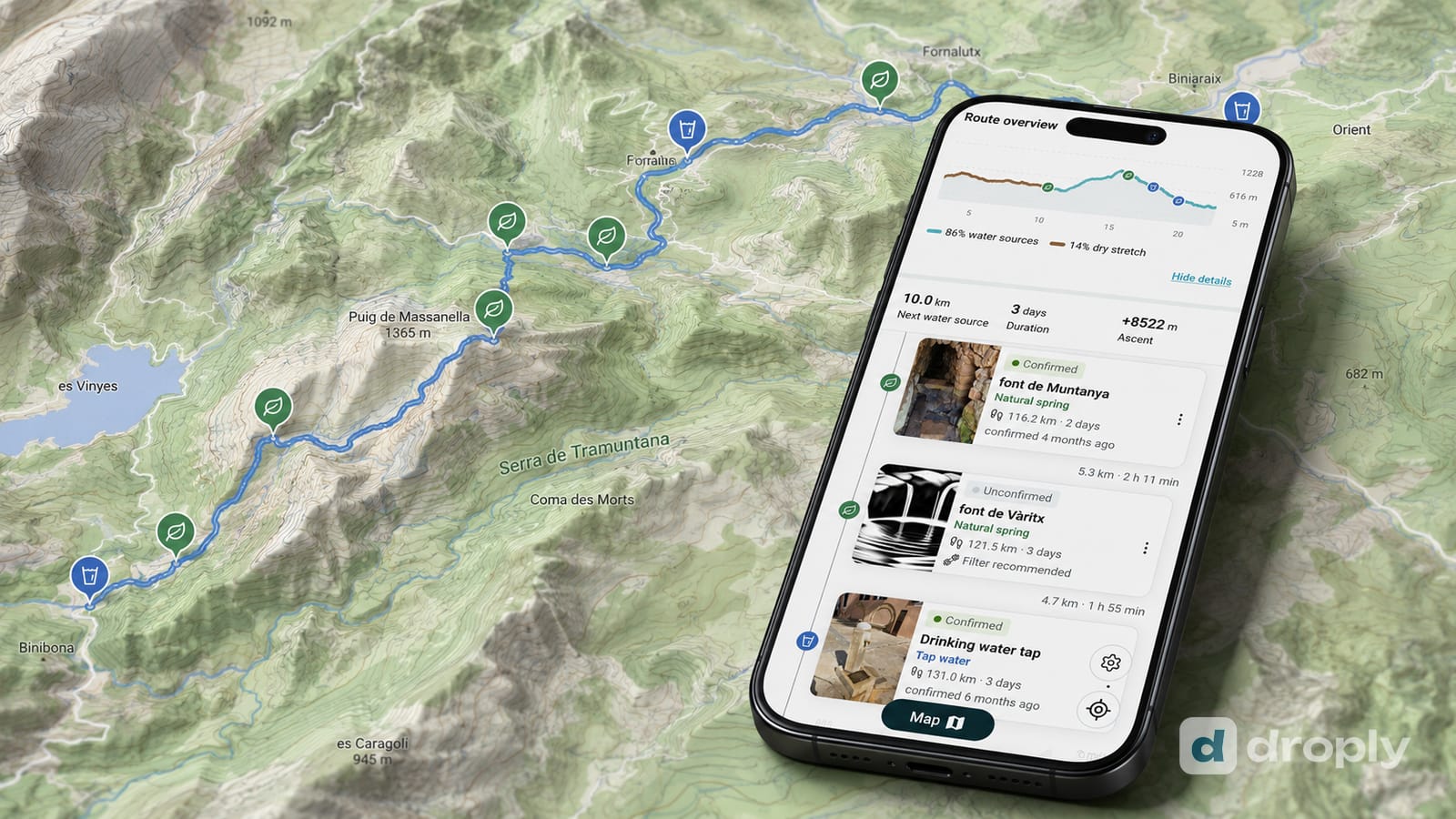
droply 2.0 is out now, and it brings droply PRO: the droply Navigator for water along your route, offline maps, and an ad-free map, built on top of a year of community water data.
TL;DR: droply 2.0 launched today, and with it droply PRO, droply’s paid tier. PRO adds the droply Navigator, which reads a GPX route and shows the water sources along it, offline maps you can download before you lose signal, and an ad-free map. It costs around 29 EUR once or around 9.80 EUR a year, with no monthly plan and no trial, and contributors with 100 or more droply points can claim a full year for free. droply, including PRO, is available now for iOS and Android.
droply 2.0 is out today, and it’s the biggest release since droply started: droply PRO, a paid tier built around one idea, knowing what water is ahead of you on a route you already have.
What’s new in droply 2.0?
droply 2.0 keeps the free map exactly as it was, every water source, check-in, photo and comment stays free for everyone, and adds droply PRO on top of it. PRO is built from two features: the droply Navigator, which turns a GPX route into a water timeline, and offline maps, which pin the water along that route to your phone before you lose signal. Both come with an ad-free map.
None of this replaces the free version. It’s what a year of requests and our own hikes kept pointing toward: people don’t just want to find water near them, they want to know what’s coming up on the route they’re already walking.
How does the droply Navigator work?
You upload the GPX file of a route you already have, and the Navigator searches a corridor along it for water sources droply already knows about. It reads back a simple timeline: the next water source and how far away it is, how much of a detour it costs to reach, and where the dry stretches are, so you know in advance where to carry more.
The Navigator isn’t a new route planner. You bring the route, whether you built it yourself, downloaded it from a trail provider, or got it from a friend, and it adds one layer: what does this route look like from a water perspective.
“We didn’t build this because it belonged on a roadmap,” said Nathalie, droply’s co-founder and product designer. “We built it because on our next long trail, it’s what we’d actually want to open.”
What does offline mean in droply PRO?
Download your route before you lose signal, and the water sources along it are pinned to your phone, so the Navigator keeps working with no connection at all. This isn’t the whole map working offline everywhere: it’s the water along the specific route you downloaded, which is the part that matters once you’re actually walking it.
Why does the community data matter here?
The Navigator is only as good as the water information behind it, and that information comes from droply’s community, not from us. Hikers, cyclists and travelers check in at water sources to say whether they’re flowing, upload photos, fix wrong details and leave comments for whoever passes next.
“When a spring is marked on a map, that’s a starting point, not a guarantee,” said Micha, droply’s co-founder. “What makes it useful is somebody telling you they stood there last week and it was flowing.”
A route full of water sources nobody has checked in months is a much weaker read than one people are actively keeping current. That’s the layer PRO builds on, and it’s why the free contribution tools that built droply’s map aren’t changing.
What does droply PRO cost?
droply PRO has two options: around 29 EUR once, paid a single time with no expiry and no subscription, which unlocks every PRO feature we add in the future too, or around 9.80 EUR a year, billed annually. There’s no monthly plan and no free trial. Prices vary by country, so treat the EUR figures here as an indication, not the exact price you’ll see at checkout.
Contributors don’t have to pay at all. If you have 100 or more droply points from check-ins, photos, corrections and other contributions, choose “I have droply points” at checkout and get a full year of droply PRO. It’s a thank-you for what you’ve already added to the map, not a discount.
Where can I get droply 2.0?
droply 2.0, including droply PRO, is available now for iOS and Android. Update the app or install it from the App Store or Google Play.
For the story behind why we built the Navigator, read the droply Navigator: the feature we wished we had on the trail.
About droply
droply is a free, community-maintained map of water sources for hikers, cyclists, travelers and anyone else who wants to know where to fill a bottle. People add, check and photograph fountains, springs, taps and other water sources, and droply PRO builds route planning and offline use on top of that shared map. droply was founded by Micha and Nathalie, two CDT thru-hikers, and is available on iOS and Android.
Frequently asked questions
What is droply 2.0?
droply 2.0 is the current version of droply, the community water-source map for hikers, cyclists and travelers. It’s the release that introduces droply PRO, droply’s first paid tier, alongside the free map that stays free for everyone.
What is droply PRO?
droply PRO is droply’s paid tier. It adds the droply Navigator, which shows the water sources along a route you upload as a GPX file, offline maps and downloads, and an ad-free map. The free version of droply keeps working exactly as before.
How much does droply PRO cost?
droply PRO costs around 29 EUR once, paid a single time with no expiry, for lifetime access to every PRO feature we add later too, or around 9.80 EUR a year, billed annually. Local pricing varies by country. There’s no monthly plan and no free trial. Contributors with 100 or more droply points can claim a full year of PRO for free instead of paying.
Is droply PRO available on iOS and Android?
Yes. droply 2.0, including droply PRO, is available now on both the App Store and Google Play.
How do I get droply PRO for free with droply points?
If you have 100 or more droply points from check-ins, photos, corrections and other contributions, choose “I have droply points” at checkout instead of paying, and you get a full year of droply PRO.
Do I need droply PRO to use droply?
No. droply’s map, water sources, check-ins, photos and comments stay free for everyone. droply PRO is an optional layer on top, for route planning and offline use.
Frequently asked questions
What is droply 2.0?
droply 2.0 is the current version of droply, the community water-source map for hikers, cyclists and travelers. It's the release that introduces droply PRO, droply's first paid tier, alongside the free map that stays free for everyone.
What is droply PRO?
droply PRO is droply's paid tier. It adds the droply Navigator, which shows the water sources along a route you upload as a GPX file, offline maps and downloads, and an ad-free map. The free version of droply keeps working exactly as before.
How much does droply PRO cost?
droply PRO costs around 29 EUR once, paid a single time with no expiry, for lifetime access to every PRO feature we add later too, or around 9.80 EUR a year, billed annually. Local pricing varies by country. There's no monthly plan and no free trial. Contributors with 100 or more droply points can claim a full year of PRO for free instead of paying.
Is droply PRO available on iOS and Android?
Yes. droply 2.0, including droply PRO, is available now on both the App Store and Google Play.
How do I get droply PRO for free with droply points?
If you have 100 or more droply points from check-ins, photos, corrections and other contributions, choose "I have droply points" at checkout instead of paying, and you get a full year of droply PRO.
Do I need droply PRO to use droply?
No. droply's map, water sources, check-ins, photos and comments stay free for everyone. droply PRO is an optional layer on top, for route planning and offline use.
Published on
← Back to blog  By Nathalie · Co-Founder & Product Designer, droply
CDT (2024) & PCT (2018) thru-hiker · Co-founder & product designer, droply
Nathalie co-founded droply and designs its UI and UX. A passionate ultralight hiker who thru-hiked the CDT in 2024 and the PCT in 2018, she's always happy to carry less water, and to photograph a beautiful fountain along the way.
Get new posts in your reader
New guides and trail notes land in your feed reader the day they're published. No email address, no account, no tracking.
Feed address
https://droply-app.com/rss.xml