


· Micha
Hiking the Mullerthal Trail with the droply water navigator
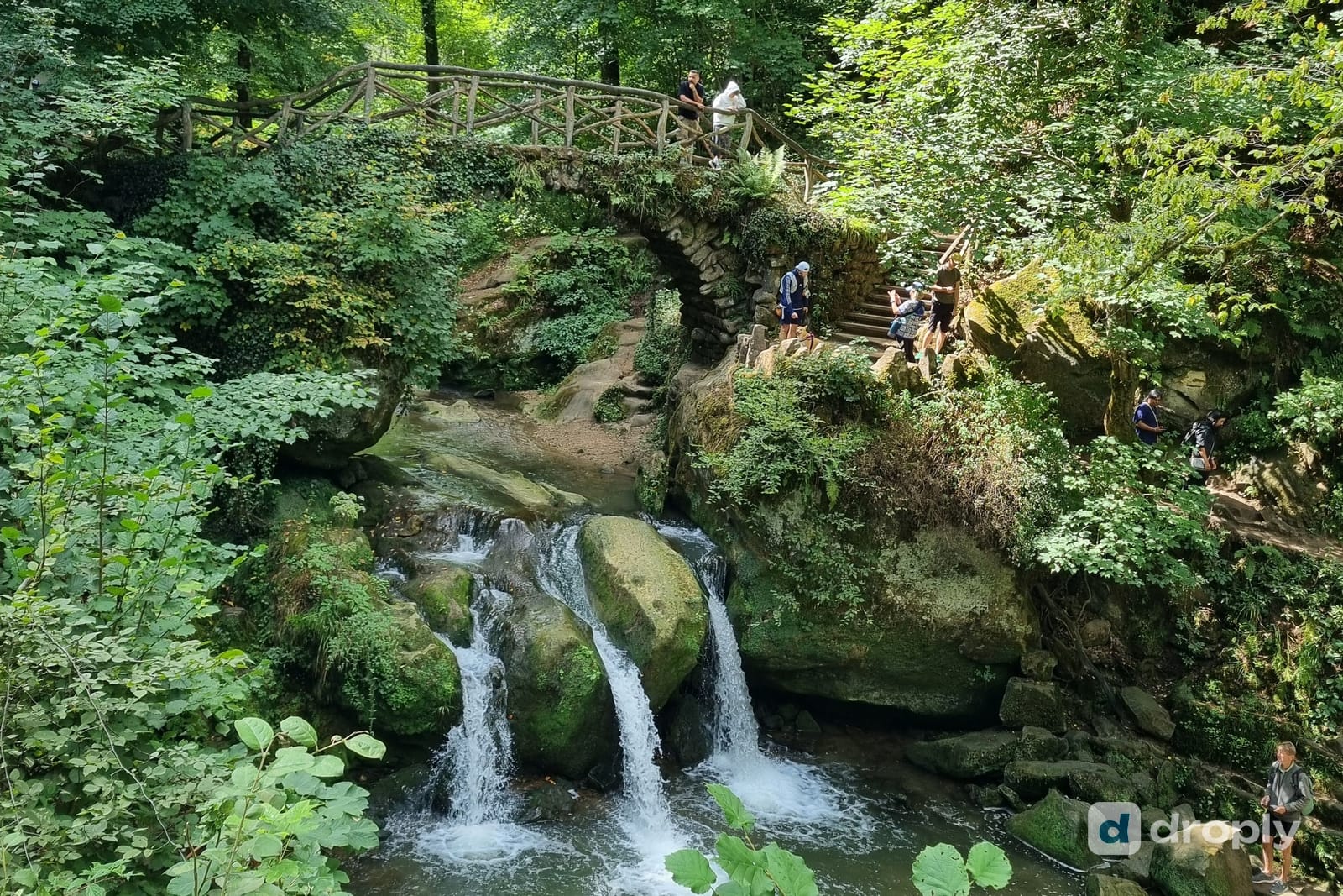
A day on route 2 of the Mullerthal Trail in Luxembourg: 39 km of canyons and forest, one single tap, and what the droply Navigator could and couldn't do about it.
Route 2 of the Mullerthal Trail is a 39 km loop through Luxembourg’s sandstone canyons, and it has exactly one tap on it. I walked it in August with the route loaded in droply, the first full day I spent with the droply Navigator since we launched it. Here is what worked, what the app couldn’t fix, and what I’d do differently.
What is the Mullerthal Trail, and what is route 2?
The Mullerthal Trail is a set of three circular hiking routes in eastern Luxembourg, in the Mullerthal region, also called Little Luxembourg Switzerland. Each loop is roughly 37 km. Route 2 starts and ends at the basilica in Echternach, covers 39.7 km with 387 m of ascent, and passes through Berdorf, Mullerthal, Hersberg and Scheidgen.
Those numbers tell you what kind of day it is. Under 400 m of climbing over almost 40 km is flat, so the distance is what makes it long, not the ascent. The official description splits the route into two day stages. I walked it in one, which took most of the daylight.
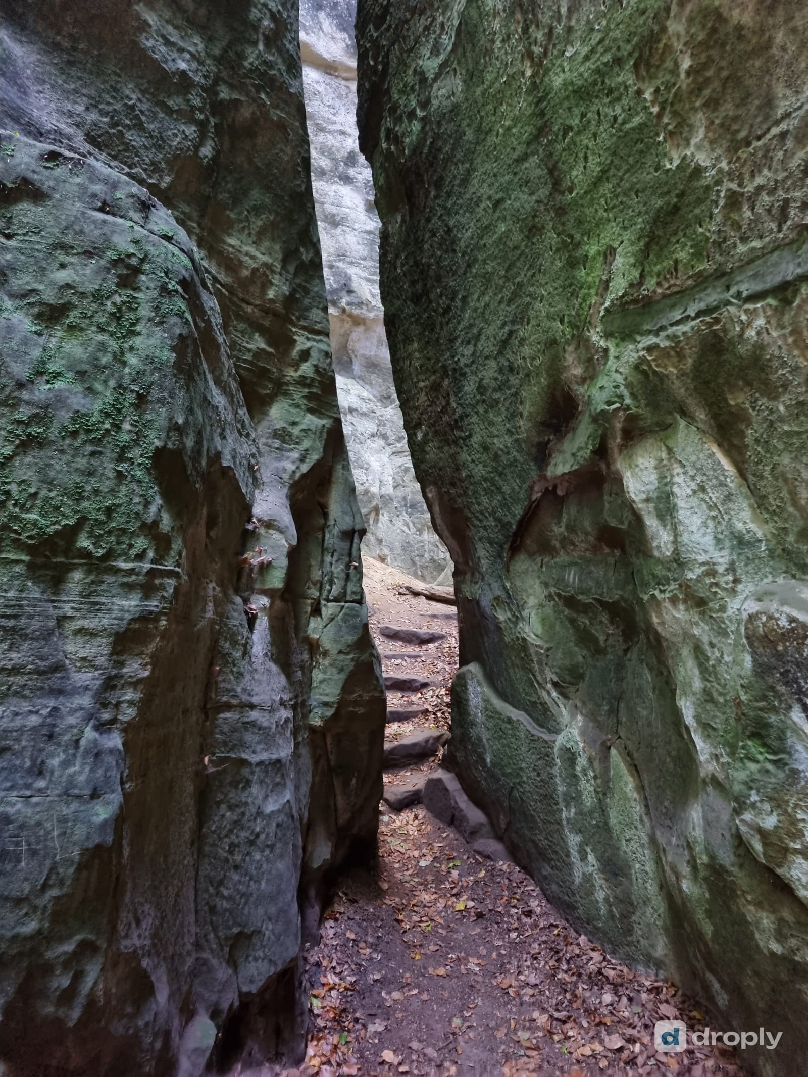
The route stays in forest nearly the whole way. It runs between sandstone walls, past the Schéissendëmpel, a small waterfall under a stone bridge, and through narrow rock fissures like the Kuelscheier and the Wollefsschlucht. In August, that shade is the reason to walk here rather than somewhere open. It also makes the whole place look wet, which has very little to do with what you can put in a bottle.
Summary: route 2 is a 39.7 km forest loop from Echternach with almost no climbing, spectacular rock passages, and a long day’s walking if you do it in one go.
How do you get a trail into droply?
You upload the route’s .gpx file, and droply searches a corridor along the track for water sources it already knows. I found the file on the official Mullerthal Trail website, which offers GPX and KML downloads for each route. That’s usually the easy part: most official trail sites publish their tracks, and I’ve rarely had to build one myself.
The upload worked without any trouble. Two things came up that are worth knowing before you try it.
The file carried no elevation data. droply reads the height information out of the file rather than inventing it, so the profile in the Navigator came out as a flat line. For route 2 that’s nearly true anyway, but it’s still missing information, and it’s the kind of thing you only notice once the route is uploaded. If your file has heights in it, you get the real profile.
The second one saved me more than it sounds. I walked the loop in the opposite direction to the official signposting, so I reversed the route direction in droply. Every distance, the order of the water sources and the countdown to the next one are then calculated from where I actually started. Without that, the tap at 7 km would have shown up at 32 km.
Summary: the GPX upload is straightforward and official trail sites usually provide the file, but droply can only show the elevation your file contains, and reversing the direction is worth doing before you rely on any of the distances.
What water did droply actually find on route 2?
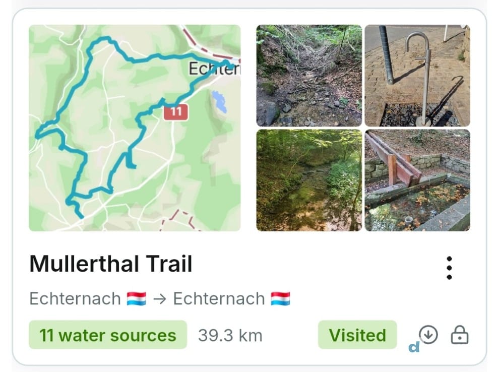
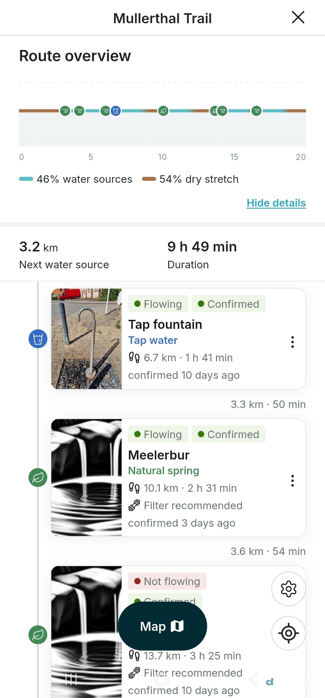
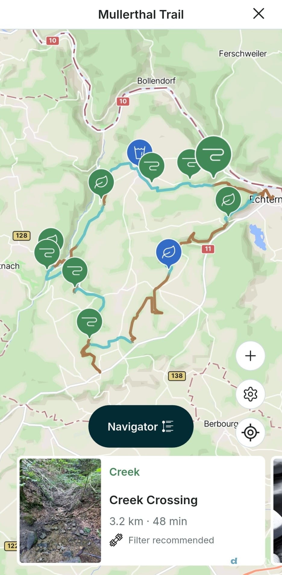
Eleven water sources along the route, and one of them was a tap. The other ten are creeks, crossings of the Schwarze Ernz river, and springs. droply counted a bit under half the route as being within reach of water and the rest as dry stretch, but that number includes every creek, not only the water you’d drink without thinking about it.
So the honest read of the screen was: one tap in 39 km, at about 7 km from my start, and after that nothing certain.
That turned out to be almost exactly right. I walked the whole loop and saw no other tap. The only other water I found was a piped natural spring, which I added to droply while standing in front of it. It’s on the map now for whoever walks route 2 next.
This is the part I want to be clear about, because it’s easy to blame the app. droply didn’t have thin data here. The trail is dry. If there’s no water along a route, no app can put it there. What droply did was tell me that the evening before, while I was still standing at the sink at home deciding how much to carry.
Summary: droply showed 11 water sources but only one tap, and a full day of walking confirmed it. The map wasn’t missing water, the trail simply doesn’t have much.
Was it still useful with only one tap?
Yes, and mostly before I left. Knowing there was one tap in 39 km is what decided how much water went into the pack, and on a warm August day that’s the difference between a comfortable walk and a bad afternoon.
I also carried a water filter, the small squeeze type that screws onto a bottle. I didn’t use it. But I knew from droply where the river crossings and the spring were, and that changes what those creeks mean. They stop being scenery and become a backup for the case where it gets hotter than forecast, or the day runs longer than planned. Forest creeks in late summer are not something to count on, so the plan was the tap plus what I carried, with the creeks as the fallback behind it. If you want the detail on treating water like that, we wrote a guide to hiking water filters.
Summary: on a dry route the value sits in the planning, not in the refills. One tap in 39 km is a number you want before you pack, and the creeks are worth knowing about even if you never touch them.
Did I use it on the trail, or only for planning?
Both, and the second one surprised me. The Mullerthal Trail is well signposted, so I never needed a map to stay on the route. But the track was already in droply, with my position on it, so droply became the app I opened when I wanted to know how far around the loop I was.
That lines up with what we wrote when we launched the Navigator: less map, more of what’s coming up. On a trail that’s already marked, it turns out you don’t need much more than that.
Summary: on a well-marked trail the Navigator covered both jobs, the water planning before the walk and a simple sense of position during it.
What trails have you hiked with droply?
This is the part where I’d rather hear from you than keep talking. We built the Navigator for exactly this kind of day, and route 2 was a hard test of it: a beautiful trail with almost nothing to drink on it.
So tell us what you’ve walked with it. What was useful, what got in the way, what you expected to see and didn’t. We’re a small team and we read all of it, and the Navigator is still young enough that your feedback changes what gets built next.
And if you’ve hiked a trail, put your water sources on the map. One check-in is enough. Say whether the tap was running, add the spring nobody has marked yet, upload a photo of what it looks like so the next person recognises it. The map of the Mullerthal Trail is a little better today than it was in August, and that’s one spring and one afternoon of walking.
That’s the whole idea: the more water along a trail that’s known, the less anyone has to carry.
Frequently asked questions
Is there drinking water on route 2 of the Mullerthal Trail?
Very little. On the whole 39 km loop there is one tap, in a village on the route, plus a piped natural spring. Everything else marked along the trail is creeks and the Schwarze Ernz river, which need treating before you drink them. Plan to carry water for most of the day.
How long is route 2 of the Mullerthal Trail?
The official route is 39.7 km with 387 m of ascent, starting and ending at the basilica in Echternach. The GPX file measured 39.3 km in droply. It is flat by hiking standards, so the length is what makes it a long day, not the climbing.
Do you need a water filter on the Mullerthal Trail?
You don’t need one if you carry enough water and stop at the tap, which is what most people do. A filter is what turns the creeks and the river into a backup if the day gets hotter or longer than planned. On a route this dry, that backup is worth the 100 grams.
Can you upload a GPX file without elevation data to droply?
Yes, and the water part works normally. droply reads elevation from the file rather than inventing it, so a file without height data gives you a flat profile. The water sources, distances and dry stretches are all calculated from the track itself and are unaffected.
Can you hike a route in the opposite direction in droply?
Yes. Open the route settings and choose Reverse direction. All the distances, the order of the water sources and the next-water countdown are recalculated from your actual starting point, which matters when you walk a signposted loop the other way round.
Frequently asked questions
Is there drinking water on route 2 of the Mullerthal Trail?
Very little. On the whole 39 km loop there is one tap, in a village on the route, plus a piped natural spring. Everything else marked along the trail is creeks and the Schwarze Ernz river, which need treating before you drink them. Plan to carry water for most of the day.
How long is route 2 of the Mullerthal Trail?
The official route is 39.7 km with 387 m of ascent, starting and ending at the basilica in Echternach. The GPX file measured 39.3 km in droply. It is flat by hiking standards, so the length is what makes it a long day, not the climbing.
Do you need a water filter on the Mullerthal Trail?
You don't need one if you carry enough water and stop at the tap, which is what most people do. A filter is what turns the creeks and the river into a backup if the day gets hotter or longer than planned. On a route this dry, that backup is worth the 100 grams.
Can you upload a GPX file without elevation data to droply?
Yes, and the water part works normally. droply reads elevation from the file rather than inventing it, so a file without height data gives you a flat profile. The water sources, distances and dry stretches are all calculated from the track itself and are unaffected.
Can you hike a route in the opposite direction in droply?
Yes. Open the route settings and choose Reverse direction. All the distances, the order of the water sources and the next-water countdown are recalculated from your actual starting point, which matters when you walk a signposted loop the other way round.
Published on
← Back to blog  By Micha · Co-Founder, droply
CDT thru-hiker (2024) · Co-founder of droply
Micha co-founded droply after thru-hiking the Continental Divide Trail in 2024. A former scout and lifelong outdoor enthusiast, he's always chasing water sources to map: hidden natural springs and hot springs are his favorites.
Get new posts in your reader
New guides and trail notes land in your feed reader the day they're published. No email address, no account, no tracking.
Feed address
https://droply-app.com/rss.xml